NYT Top Stories - Latest Updates
Strikes, Barricades and Fiscal Turmoil: An Autumn of Discontent Grips France
Potential Iranian Drone Attack Led to Exit of U.S. Bombers From U.K. Air Base RAF Fairford
Man Arrested in Connection With Incident at UK Air Base RAF Fairford
Trump Suggests Iran Could ‘Take Out’ L.A. or San Diego, Drawing Anger From California Leaders
BBC World News - Latest Updates
Former German spy chief arrested for espionage and treason
Ship sinks and crew missing after Black Sea drone attack
White House defends Trump comment to let Iran 'take out' LA and San Diego
Lawyer for one of Cornell 7 calls for special prosecutor to be removed over previous comments
NPR National - Latest Updates
Here are the finalists for the 2026 National Book Awards

Three-time National Book Award finalist Edwidge Danticat and debut novelist Morgan Thomas are up for the fiction prize. Nonfiction books cover the prison system and music, and queer parenthood.

What to know about nationwide protests in India over voter list changes

The campaign is led in part by India's "Cockroach" youth movement, which previously forced the education minister to resign.
(Image credit: Rafiq Maqbool)

Vietnamese police arrest 12 suspected of prowling city streets at night, snatching cats for meat

State media cited investigators who said the network recruited people to ride motorcycles through neighborhoods at night, trapping up to 10 cats a night.
(Image credit: Humane World for Animals)

Ex-spy chief is arrested in Germany on suspicion of trading state secrets and treason

A former head of Germany 's foreign intelligence service was arrested on suspicion that he had passed state secrets to a foreign intelligence service, the federal prosecutor's office said.
(Image credit: Michael Kappeler)

Wired - Latest Updates
The 24 Best Prime Day Deals Under $100 (2026)
‘Mike Rogers Is Watching You’: New Ad Blitz From Abdul El-Sayed Attacks Surveillance Support
OpenAI Is Pissing Off a Bunch of Mathematicians—Again
Best October Prime Day Mattress and Bedding Deals (2026)
NASA Breaking News - Latest Updates
Astronomers Solve Cosmic Cold Case with NASA Hubble Data
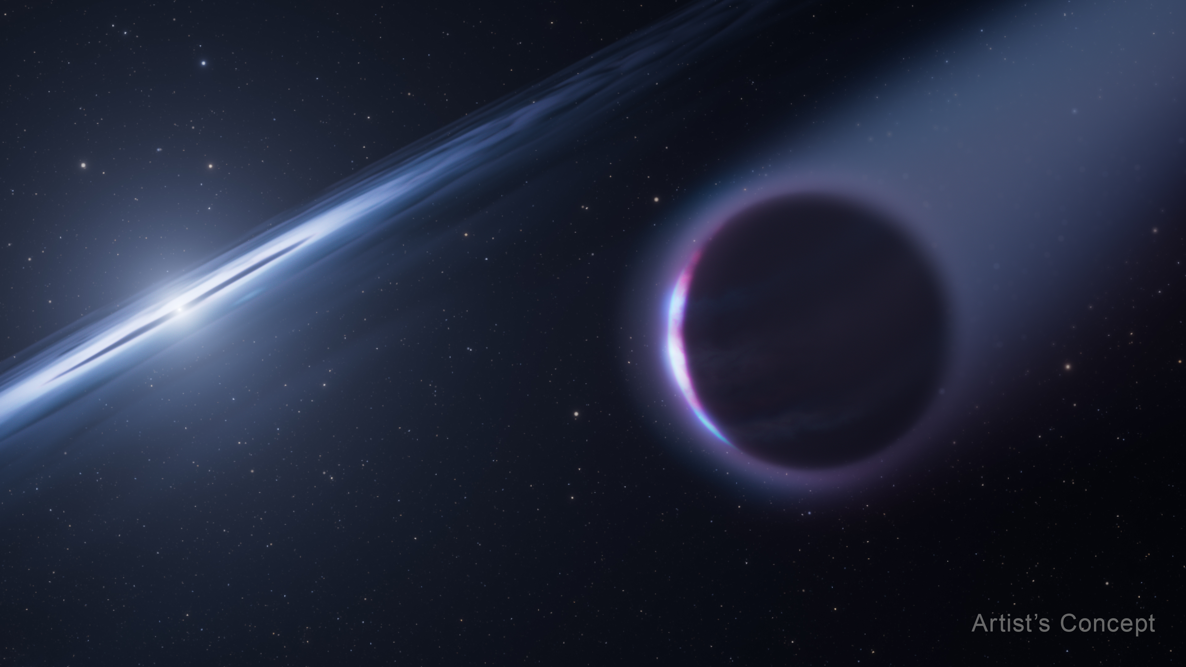
Diligent sleuthing by astronomers uncovered a surprising chemical clue that indicates the white dwarf star HS 0209+0832 may host a second-generation planet. This artist’s concept released on Oct. 5, 2026, depicts that possible explanation.
The white dwarf is the “dead” core of a star that burned through all of its nuclear fuel and lost its outer envelope of gas and dust to space. The second-generation planet formed from that cast-off gas and dust, which is why its chemical content is very different from a planet that formed as its host star was forming.
Learn more about this scientific discovery.
Image credit: NASA, ESA, Leah Hustak (STScI)
NASA’s Curiosity Rover Catches Stunning Martian Dawn
3 min read
Preparations for Next Moonwalk Simulations Underway (and Underwater)
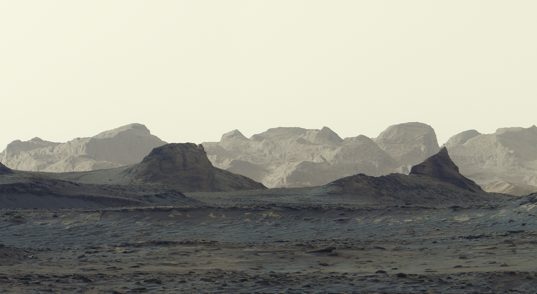
A newly released panorama captured by NASA’s Curiosity rover offers the most detailed view yet of distant, wind-carved Martian cliffs, highlighting features the mission’s scientists have long been waiting to see up close. The scene was snapped at 8:30 a.m. local Mars time, showing striking blue hues in the foreground as bright morning light illuminates crags known as yardangs on the horizon.
The panorama was captured by Curiosity’s Mastcam on Aug. 11, the 4,982nd Martian day, or sol, of the mission, and comprises six individual images that were stitched together after being sent to Earth. Unlike most of Curiosity’s Mastcam images, this one was processed without white balancing, preserving the early morning appearance.

The yardang layer extends roughly 10 miles (16 kilometers) across the northwestern reaches of Mount Sharp, a 3-mile-tall (5-kilometer-tall) mountain that Curiosity has been ascending since 2014. In fact, the rover recently passed another milestone in its ascent, reaching 0.6 miles (1 kilometer) of elevation — the most ever climbed on Mars. As it draws ever-closer to the yardangs, mission scientists expect to get even more amazing imagery — and, they hope, answers to how these cliffs were created.
Mount Sharp is made up of layers, each recording a distinct period of Mars’ history. By studying them, scientists have been able to learn more about lakes and streams that covered this part of the Red Planet billions of years ago. Eventually, the water dried up and left salty minerals behind. After new material stopped settling on the mountain, some of it may have been stripped away by wind, giving rise to the yardangs.
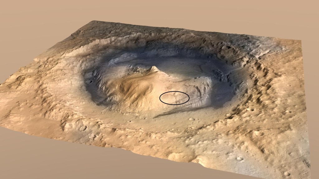

“The yardang layer looks out of place. It’s the wrong color, the layers tilt at an odd angle, and it almost appears plastered on,” said Ashwin Vasavada, Curiosity project scientist of NASA’s Jet Propulsion Laboratory in Southern California. “But that’s what makes it exciting to reach. No one is sure exactly what created this layer, but one idea is it may be ash deposited by ancient volcanic eruptions.”
Curiosity is in the second year of its fifth extended mission, which started with an exploration of the spiderweb-like boxwork ridges. The rover will spend most of the next year or so driving through layers enriched with sulfates and carbonates, both signs of ancient drying on the surface. Sometime in 2027, scientists hope to reach the base of the yardangs, where Curiosity will be able to use its robotic arm to collect one-of-a-kind data on these mysterious features.
More about Curiosity
Curiosity was built by NASA JPL, which is managed by Caltech in Pasadena, California. NASA JPL leads the mission on behalf of the agency’s Science Mission Directorate in Washington as part of its Mars Exploration Program portfolio. Malin Space Science Systems in San Diego built and operates Mastcam.
To learn more about Curiosity, visit:
https://science.nasa.gov/mission/msl-curiosity
News Media Contacts
Andrew Good
Jet Propulsion Laboratory, Pasadena, Calif.
818-393-2433
andrew.c.good@jpl.nasa.gov
Karen Fox / Alana Johnson
NASA Headquarters, Washington
240-285-5155 / 202-672-4780
karen.c.fox@nasa.gov / alana.r.johnson@nasa.gov
2026-067
Share
Details
Related Terms
Explore More

NASA’s Webb Captures Commotion From Nebula’s Stellar Jets
NASA’s Webb Captures Commotion From Nebula’s Stellar Jets
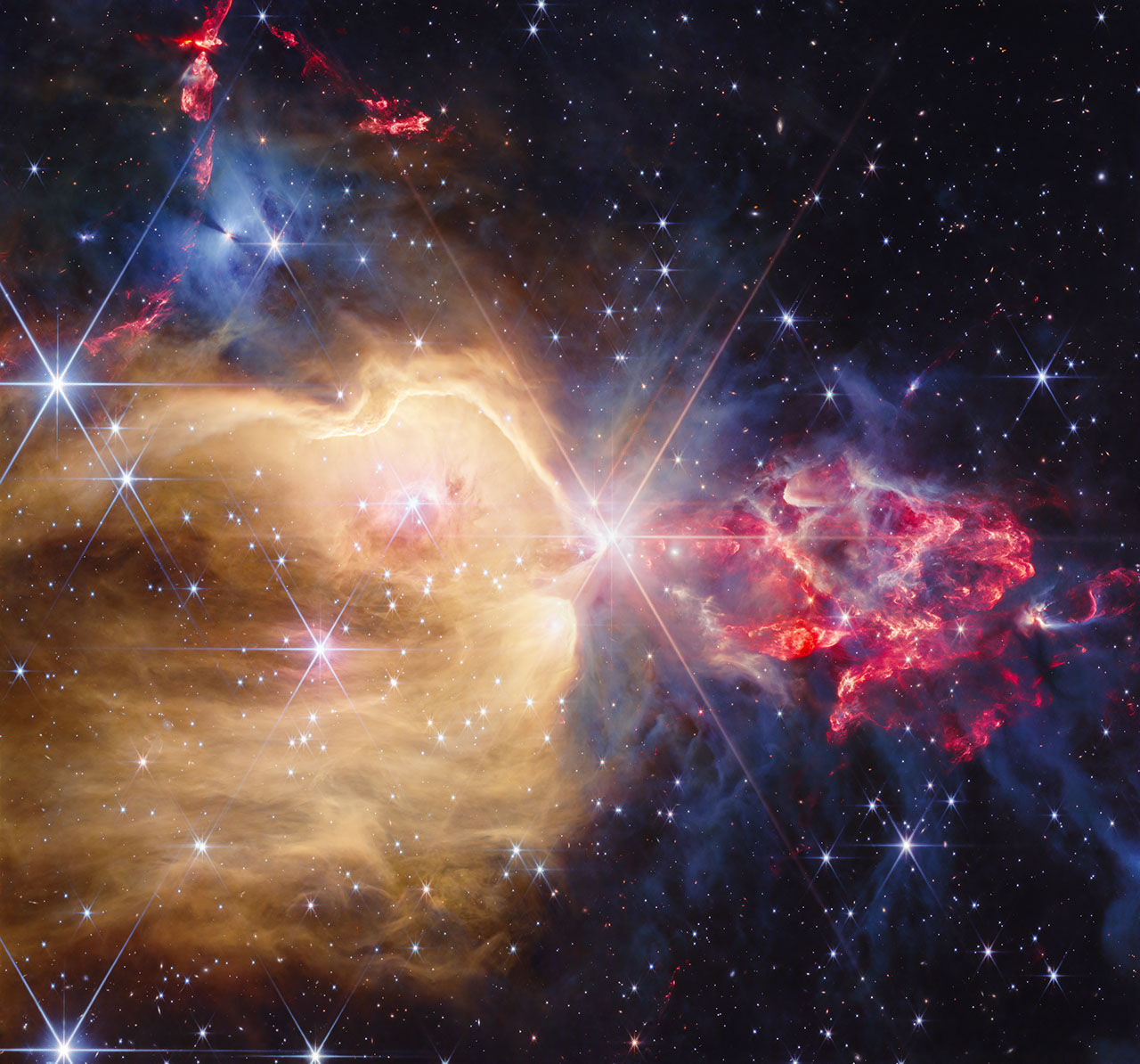
A cauldron of cosmic creation is being revealed in a new image from NASA’s James Webb Space Telescope. Webb has unveiled numerous stars formerly hidden by clouds of dust in a stellar nursery known as NGC 7129, which resides about 3,300 light-years from Earth.
Stars, the engines of elemental creation, have life cycles that begin with their birth in molecular clouds – cold, dense regions of dust and gas. Because of these dusty cocoons, young stars are often impossible to view by many telescopes, particularly those incapable of capturing infrared light. Webb, however, has a high degree of infrared sensitivity, allowing astronomers to peer through that dust and study the beginning of the star life cycle.
Image: NGC 7129 (NIRCam Image)
The stars from this cluster are in different stages of their development, as the more massive stars form and evolve the fastest. The most massive (and the most mature) is the region’s luminous central star, LkH(alpha) 234 (pronounced Lick-H-alpha). This star, which sports the image’s most prominent diffraction pattern, is a pre-main-sequence star weighing around 5 to 8 times the mass of our Sun. Pre-main-sequence stars like these have mostly finished gathering mass and are contracting under the force of gravity, causing their temperatures to rise. In time, this star will fuse its own hydrogen like our Sun.
The cavity to its left, which appears in gold and spans about 3.5 light-years, is the largest demonstration of the central star’s impact. Outflows from an earlier stage of the star’s life cycle carve into the dense molecular cloud of hydrogen. Both the outflows and the star’s light energize the gas, causing it to glow. While much of this hydrogen gas is blown away, a large amount is also compressed, creating the conditions for even more stars to form.
Interactive: The Colorful Clouds of NGC 7129
A few of these stars are visible within the cavity. Several of them are also pre-main-sequence and emit stellar winds. The nearby bow shocks, the curved compressed gas that appears near the stars, are created as those winds push into the energetic gas and create their own, smaller cavities.
Together, the central and embedded stars also create the sharp ridge seen at the top of the golden cavity. Their light generates a hot environment that pushes against the colder and denser molecular gas outside the cavity, and creates a boundary known as a photodissociation region. In this region, the molecules of hydrogen break down into atoms. By influencing the temperature and chemistry of the region, this collection of stars offers insight into how these molecular clouds will gradually erode over millions of years.
The region to the right of the central star narrates a different, but equally chaotic tale. This clumpy matter represented in red hides much younger objects than those on the left: protostars. The protostar stage is earlier than the pre-main-sequence stage and occurs after molecular clouds of gas and dust initially compress and fragment.
As the protostars accumulate matter and increase their mass, they eject outflows of superheated material. These outflows interact with the dense, gray, translucent matter the protostars are wrapped within, creating shocks that cause a textured appearance. The red glow is also the result of the interaction. Multiple outflows from multiple stars overlap from our point of view, leading to the scene’s chaotic look.
Image: NGC 7129 Side-by-Side (Spitzer and Webb Image)
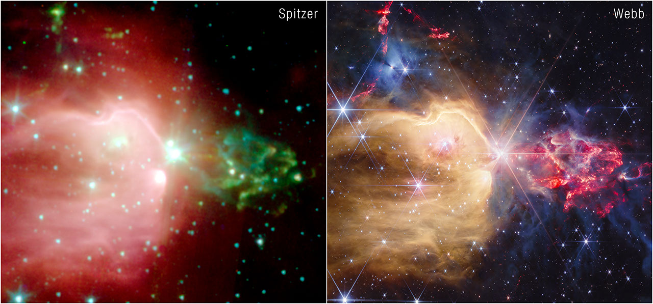
More of these protostellar outflows can be seen at the upper left of the image, near a blue-colored nebula. The center of this blue region hosts a protostar surrounded by a donut-shaped disk of material. This disk casts a shadow against the surrounding nebula, reminiscent of a similar structure known as the “Bat Shadow” that was observed by NASA’s Hubble Space Telescope.
Webb’s high spatial resolution reveals many rich structures in the region’s gas, building on research done previously by NASA’s retired Spitzer Space Telescope. Astronomers will continue to use this Webb data to study how the stars and protostars in this region influence the surrounding gas and dust.
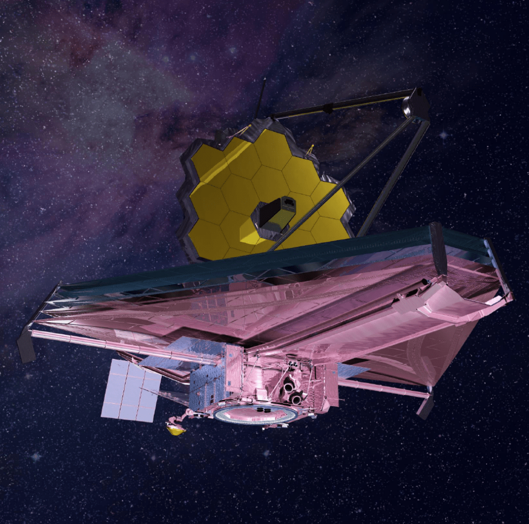
The James Webb Space Telescope is the world’s premier space science observatory. Webb is solving mysteries in our solar system, looking beyond to distant worlds around other stars, and probing the mysterious structures and origins of our universe and our place in it. Webb is an international program led by NASA with its partners, ESA (European Space Agency) and CSA (Canadian Space Agency).
To learn more about Webb, visit:
Downloads & Related Information
The following sections contain links to download this article’s images and videos in all available resolutions followed by related information links, media contacts, and if available, research paper and Spanish translation links.
Related Images & Videos
Related Links
Read more: Webb’s Star Formation Discoveries
Explore more: Image Tour: Herbig-Haro 46/47
Watch: Herbig-Haro 49/50 Stellar Jets Visualization
Explore more: Star formation in the Eagle Nebula
Watch: Celestial Lightsabers: Stellar Jets in HH24
More Webb: News | Images | Science | Home Page
Share
Details
Laura Betz
NASA’s Goddard Space Flight Center
Greenbelt, Maryland
laura.e.betz@nasa.gov
Matthew Brown
Space Telescope Science Institute
Baltimore, Maryland
Hannah Braun
Space Telescope Science Institute
Baltimore, Maryland
Related Terms

APOD: 2026 October 6 – A Complete Auroral Oval from SMILE
APOD
Astronomy Picture of the Day
Discover the cosmos! Each day a different image or photograph of our fascinating universe is featured, along with a brief explanation written by a professional astronomer.
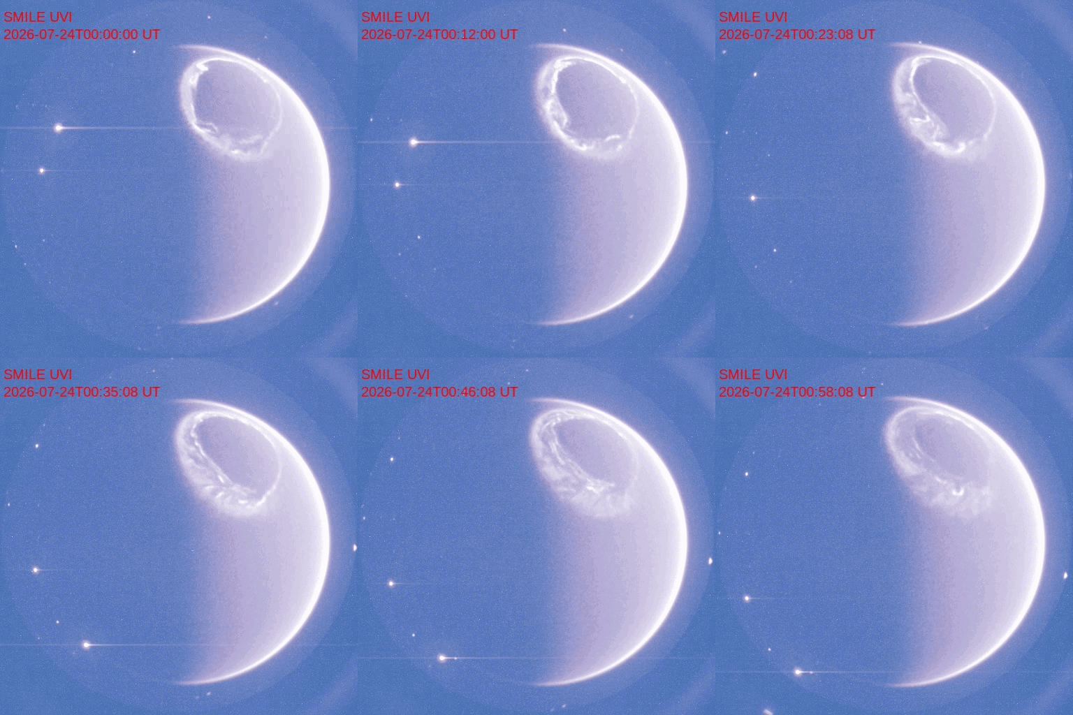
A Complete Auroral Oval from SMILE
Explanation: Have you ever seen a complete auroral oval? You can’t see one from the ground because it makes too large a circle around one of Earth’s magnetic poles. But spacecraft high above the Earth can see them. The featured video from ESA and CAS‘s robotic SMILE spacecraft shows not only a full auroral oval, but using ultraviolet light, one that occurred during the day. The time-lapse covers about an hour in late July and shows visually how variable and turbulent auroras really are. The points of light on the sides are distant stars that appear to move only because SMILE’s camera view shifts as the spacecraft orbits the Earth. A goal of SMILE is to better understand how the Sun’s wind interacts with the Earth’s magnetosphere — and so better understand how to protect astronauts, spacecraft, and ground-based electrical grids from solar storms.
Tomorrow’s picture: a spokey image
| Date: | October 6, 2026 |
|---|---|
| Credit: | ESA, CAS, SMILE, UVI |
| Authors & editors: | Robert Nemiroff, Jerry Bonnell, Cecilia Chirenti, Keighley Rockcliffe |
| A service of: |
ASD at NASA / GSFC, NASA Science Activation & Michigan Tech. U. |